
加州台裔科技人扮演「柯南」 精準定位救迷路登山客
April 28, 2021
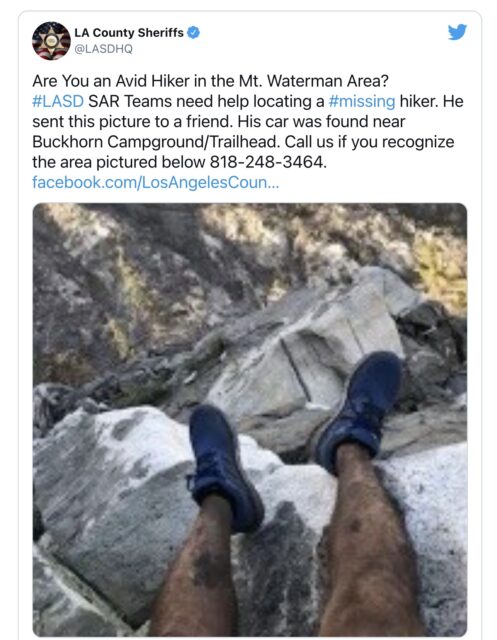
(中央社記者周世惠舊金山27日專電)當垂在岩壁上的「毛毛腳」照片是救難隊唯一的線索並上網求救時;台裔工程師郭斐品運用科技在21分鐘內比對出登山客的座標,協助束手無策的救難隊完成了不可能的搜救任務。
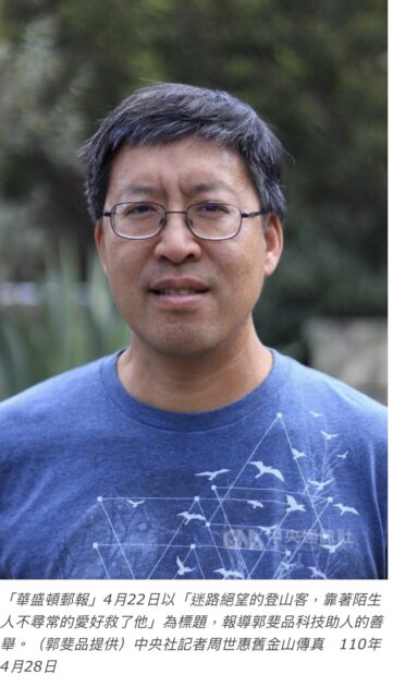
第二代台裔科技人郭斐品(Benjamin Kuo)今天接受中央社記者訪問,重述4月13日當天他如何扮演「柯南」,憑著一張網路上的「毛毛腳」照片,幫助加州的救援單位定位座標、成功找到一名迷途一夜的登山客,完成救援任務。
洛杉磯郡警長辦公室13日早上,透過社群媒體臉書和推特發布一則求救訊息,模糊的照片是一雙男性的雙腳垂在安吉利斯國家森林(Angeles National Forest)的岩壁上。這位登山客在手機沒電前,送出一則簡訊和兩張照片給朋友,一張照片沒傳成功,另一張就是「毛毛腳」。
服務於科技業、47歲的郭斐品當時正在南加州的家裡工作,看到這則推文後,熱心的他轉推訊息,並跟自己打賭「我可以找到這位置」。
同樣愛好戶外運動的郭斐品發揮「柯南」精神,從照片中的岩壁大膽研判,「這人在南邊,因為北邊沒有綠色山谷」。這項資訊讓他縮小了搜尋區域。
郭斐品接著利用衛星地圖和科技工具,包括谷歌地球(Google Earth)與歐盟的兩個衛星哨兵2號(Sentinel-2),交叉比對全景圖和原始照片的特定細節,確認這位迷路登山客的經緯度座標,過程僅花21分鐘。
「令我訝異地,他們真的接受我的建議,決定去那個地點找人」。搜救隊就在郭斐品建議座標的不到3/4英里處找到人。由於這位登山客為了讓別人看到他,稍微移動了位置,所以郭斐品原來的判讀可能幾乎百分之百正確。
搜救隊差點束手無策,因為他們從沒有僅憑一張照片進行搜救的經驗。郭斐品說:「真的很幸運,很高興他獲救。能擁有幫助別人的訊息,那很值得分享。」
郭斐品的父母於1960年代從台灣到美國求學,之後就地成家立業,郭斐品在成長過程中,印象深刻的是台灣美食、夜市和到廟裡拜拜,以及回到母親故鄉蘆洲的種種。
華盛頓郵報(Washington Post)4月22日以「迷路絕望的登山客,靠著陌生人不尋常的愛好救了他」(A hiker was lost and desperate. A stranger with an unusual hobby saved him)為標題,報導郭斐品科技助人的善舉。
經驗老道的登山客科裴恩(Rene Compean)得救後,在視訊通話時感恩地對郭斐品說,「我的命是你救的」,相約有機會兩人一起爬山。
除了科技專業,47歲的郭斐品還是一位業餘的無線電玩家,他的推特帳號就是他的無線電呼號。他善用此興趣,曾參與救援波多黎各的風災,經常在社群媒體提供加州野火相關消息。
正因為要正確判讀野火的訊息,郭斐品發現許多衛星資料和影像免費對外界開放,相關資源更是他這次找出迷蹤登山客座標時的重要工具。
從科技的角度,郭斐品建議從事戶外活動的人們善用手機內建的羅盤定位功能,另外他推薦免費網站及應用程式FindMeSAR,即使在沒有網路的深山也能使用,因為「送出有經緯度的座標求救,遠勝於腳的照片」。(編輯:韋樞/高照芬)1100428
台裔科技人郭斐品接受中央社記者專訪,分享他運用衛星資訊和科技工具協助加州的救援單位,從一張「毛毛腳」照片,經精準定位後,找到迷路一夜的登山客。中央社記者周世惠舊金山攝 110年4月28日
Source from 台灣公義報
A hiker was lost and desperate. A stranger with an unusual hobby saved him.
By Sydney Page
April 22, 2021 at 5:00 a.m. CDT
When Rene Compean snapped a photo of his soot-stained legs hanging over a steep cascade of rocks, he feared it was the last picture he’d ever take. Hopelessly lost while hiking in Southern California, he thought he might die.
“I’m not ready,” the 45-year-old man told himself as he repeatedly yelled for help and used charred sticks to write SOS on any open surfaces he could find.
Compean had trekked through the Angeles National Forest trails more times than he could count, he said, but after venturing along a new path April 12 — for what he intended to be a two-hour outing — he lost his way.
Several hours into the solo hike, after many failed attempts at getting his bearings, he was scared. The temperature was dropping fast in the remote, rugged terrain, and the winds were whipping.
Compean grabbed his cellphone, which had less than 10 percent battery remaining, and climbed to a spot where he was able to get at least one bar of signal.
“SOS. My phone is going to die. I’m lost,” Compean texted a friend, along with two photos showing where he was — though only one went through. It was the picture of his legs.
The photo offered minimal information and, given Compean’s lack of cellphone signal, the resolution was very low. More importantly, though, Compean didn’t realize his location settings were disabled on his phone.
Still, the grainy image was somehow detailed enough for a total stranger to decipher the hiker’s exact location.
Ben Kuo was working at his home about 60 miles away in Ventura County, Calif., when he stumbled upon a tweet from the Los Angeles County Sheriff’s Department, along with the photo of Compean’s legs.
The sheriff’s search-and-rescue teams had already spent the previous night unsuccessfully looking for Compean, so they released the photograph to the public hoping someone could help.
Sgt. John Gilbert said they figured Compean was on the mountain at about 7,000 feet elevation, and the blasts of wind were “definitely a concern.”
“We didn’t have any information that he was adequately prepared to spend the night out in the wilderness,” Gilbert said.
The department tweeted: “Are You an Avid Hiker in the Mt. Waterman Area? #LASD SAR Teams need help locating a #missing hiker.”
Kuo, 47, inspected the image and thought, “I bet I could find that spot,” he recalled.
Kuo works in the tech industry, but he is also an amateur radio operator. For several years, as a hobby, he has used his Twitter account to alert the public about natural disasters. He regularly examines satellite imagery to identify and track local wildfires.
Plus, he has another unusual pastime: “I have always loved looking for where photos are taken,” Kuo said. He frequently tries to identify where movie scenes, television shows or commercials were filmed. He’s often successful.
So when he came across the blurry image of Compean’s legs surrounded by an endless landscape of rocks and vegetation, he instinctively pulled up a satellite map. Since the sheriff’s department said Compean’s car was found near Buckhorn Campground, he narrowed his search to the surrounding area.
“There’s an amazing amount of information you can get from satellites,” said Kuo, who is also a hiker, though he has never visited the area where Compean was lost.
The first thing he noticed in the picture were patches of greenery. “I realized he’s got to be on the south side because there’s not really any green valleys on the north side,” he explained.
That finding tightened his search considerably and helped him zero in on one area that closely resembled the terrain in the image.
The final step was cross-referencing the original photo with Google Earth and comparing specific details.
“By punching in the time and date that the photo was taken, you can compare the view in Google Earth,” said Kuo. “They matched.”
He shared a screenshot of the satellite imagery on Twitter and called the sheriff’s department to notify officials of the coordinates he uncovered.
After vetting the findings in relation to the information they were able to glean about Compean’s whereabouts, “we felt pretty confident that Ben’s information was good,” Gilbert said. A search-and-rescue team swiftly boarded a helicopter and flew to the area.
Fortunately for Compean, Kuo was spot on.
More than a full day after he went missing, the rescuers found him less than a mile from Kuo’s predicted coordinates.
“It was very gratifying that he was saved,” Kuo said. “If you have information that could help save somebody, that’s something worth sharing.”
“Ben’s help allowed us to get to that location much sooner than we probably would have,” Gilbert said. “It made a gigantic difference in us finding him.”
For Compean, who had spent more than 27 hours alone in the wilderness, hearing the vibrating helicopter hovering above him left him in tears. He was overwhelmed with relief, he said.
“I’m safe!” Compean, who sustained just a few minor cuts and scrapes, yelled repeatedly to no one in particular.
As an experienced hiker, he said it was never his intention to veer off the trails, emphasizing that there were no signs indicating that he had entered a potentially dangerous or closed-off zone. He later wondered whether signage blocking the area had been scorched by wildfires.
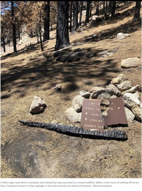
A fallen sign near where Compean was hiking that was scorched in a recent wildfire. Within a few hours of setting off on his hike, Compean found no other signage in the area and lost his sense of direction. (Rene Compean)
“I stay away from areas that are blocked or have signs that prohibit entry,” Compean said, adding that Angeles National Forest officials are reportedly investigating whether he entered a fire closure zone, though no one has contacted him directly.
He described his time alone in the mountains — with no flashlight and only a liter of water and a power bar in his backpack — as terrifying.
“I didn’t want to give up,” Compean said, adding that he kept trying to climb higher to make himself more visible. “I didn’t know if I would have made it another day there because I probably would have fallen trying to get to a higher peak.”
He yelled for help over and over, even as it seemed futile.
“It would just echo into the mountains, and I wouldn’t get anything in return,” said Compean, who eventually lost his voice.
He spent the night on high alert after spotting two mountain lions and a bear, he said, keeping a big stick and some sharp rocks beside him in case an animal came close.
Dressed in a tank top, shorts and a hoodie, Compean was chilled to the bone. He hugged himself into a tight ball, using his backpack to shield his bare legs from the frigid gusts that pounded him.
Gilbert said calls about lost hikers “is a common problem for our department,” adding that his team responded to 162 incidents last year.
To avoid running into potentially life-threatening problems, Gilbert encourages hikers to plan their route in advance and let someone know the trail they intend to take. He also suggests bringing a paper map since cellphone battery is finite, and investing in a personal locator beacon — which works in remote regions where cell service does not.
Compean’s story probably would have ended very differently, Gilbert said, had a total stranger with strong satellite skills and a sharp eye for detail not taken immediate action.
In fact, when Compean was finally pulled safely into the hovering helicopter, one rescuer wrote on a piece of paper, “You are so lucky.”
After the crew touched down and the hiker notified his family and friends that he was safe, the rescuers told him that Kuo was instrumental in helping to pinpoint his precise location.
Compean, who works as a mechanic, asked for the stranger’s contact information and set up a virtual meeting the next day to express his gratitude.
“I owe you my life,” Compean told Kuo during the Zoom call.
The two are hoping to meet in person next week for a celebratory meal.
“Maybe we’ll even go on a hike,” said Compean, adding that despite his near-death experience, he intends to revisit Angeles National Forest, his favorite hiking destination. But going forward, he vowed to be better prepared.
“I love the outdoors. I won’t let anything deter me from doing what I love,” he said
Above all, though, “I’m so lucky that Ben did what he did,” Compean said. “I’m thankful to be alive.”

Source from Washington Post
Posted on 04/29/2021


 to receive 2023 Sachem Award | 12/2023")